
KNOXVILLE, TN, June 13, 2026 /24-7PressRelease/ — A research team has developed an artificial intelligence (AI)-enabled method that can map river depth across long reach with high sediment concentration, where conventional satellite bathymetry often struggles. The model, named RivDepth, combines Sentinel-2 satellite spectral information with an optically derived suspended sediment concentration (SSC) proxy to retrieve water depth pixel by pixel. Tested in the lower Yellow River, one of the world’s most sediment-laden rivers, the model captured complex links among water depth, reflectance, and sediment load with high accuracy. The approach offers a new way to monitor underwater river topography, supporting flood assessment, sediment budget, channel management, and integrated river management.
Researchers from the State Key Laboratory of Hydroscience and Engineering at Tsinghua University, the State Key Laboratory of Water Cycle and Water Security in River Basin, and the State Key Laboratory of Simulation and Regulation of Water Cycle in River Basin at the China Institute of Water Resources and Hydropower Research conducted the study, which was accepted for publication (DOI: 10.1016/j.ese.2026.100711) on May 20, 2026, in Environmental Science and Ecotechnology. The article reports a satellite-based artificial intelligence (AI) framework for mapping river depth in high-SSC environments.
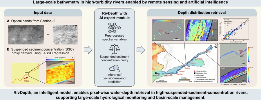
The team applied RivDepth to an approximately 786-kilometer reach of the lower Yellow River, from Xixiayuan to Lijin. They used Sentinel-2 Level-2A imagery, field-measured cross-sectional elevation data, water-level records, and in situ SSC observations to construct training and validation datasets. Water bodies, channel centerlines, thalwegs, and river widths were extracted from satellite imagery, while cloud-affected pixels were reconstructed to improve coverage. RivDepth’s innovation lies in its adaptive AI expert module, which integrates parallel random forest (PRF), extreme gradient boosting (XGBoost), support vector regression (SVR), and multilayer perceptron (MLP). Rather than applying a single model uniformly to all pixels, RivDepth performs preliminary prediction, inference, and decision-making to select the most suitable strategy for each water condition. Shapley additive explanations (SHAP) analysis identified shortwave infrared bands, red and red-edge bands, the water vapor band, the aerosol/blue band, and the SSC proxy as key predictors.
By learning different depth–reflectance–SSC patterns and choosing prediction strategies at the pixel level, the model can adapt to spatially changing sediment and channel conditions. This is particularly important for rivers such as the Yellow River, where suspended sediment, flow structure, and optical signals vary sharply over long distances. The method turns routine satellite observations into actionable depth information for river science and management. More frequent and continuous bathymetric information could help track channel change, identify thalweg migration, improve sediment-transport modeling, and support flood-risk and habitat assessments. RivDepth can be further improved as higher-resolution satellite imagery and more accurate spatial SSC indicators become available. With broader validation, the workflow may be adapted to other turbid river systems, offering a scalable tool for integrated watershed monitoring and management.
References
DOI
10.1016/j.ese.2026.100711
Original Source URL
https://doi.org/10.1016/j.ese.2026.100711
Funding information
This work was supported by the Team Key Project of the State Key Laboratory of Hydroscience and Engineering (No. sklhse-TD-2024-E01), and the National Natural Science Foundation of China (U2243218, U2243222).
About Environmental Science and Ecotechnology
Environmental Science and Ecotechnology (ISSN 2666-4984) is an international, peer-reviewed, and open-access journal published by Elsevier. The journal publishes significant views and research across the full spectrum of ecology and environmental sciences, such as climate change, sustainability, biodiversity conservation, environment & health, green catalysis/processing for pollution control, and AI-driven environmental engineering. The latest impact factor of ESE is 14.3, according to the Journal Citation ReportsTM 2024.
Chuanlink Innovations, where revolutionary ideas meet their true potential. Our name, rooted in the essence of transmission and connection, reflects our commitment to fostering innovation and facilitating the journey of ideas from inception to realization.
Related Link:
http://chuanlink-innovations.com
—
For the original version of this press release, please visit 24-7PressRelease.com here
Legal Disclaimer: The content on this page is syndicated from independent third-party providers. Kyrion Media makes no warranties or representations regarding the accuracy, completeness, legality, or reliability of the information, including text, images, videos, or licenses. If you are affiliated with this content or have any complaints, copyright concerns, or requests for removal, please contact us at retract@kyrionmedia.com with the specific URL of the content in question. We will review and address valid requests promptly.